Chiricahua National Monument
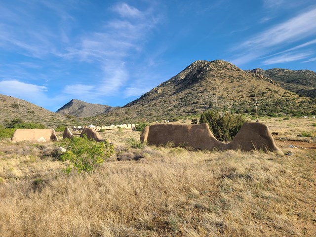
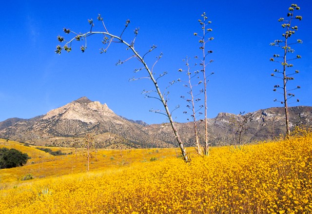
Explore rhyolite pinnacles and balanced rocks on foot or by car. Relax at the campground under star-filled, dark skies. See how a mountain range rising between two deserts creates a home for diverse wildlife. Imagine history here. Prehistoric peoples, Apaches, Buffalo Soldiers, Civilian Conservation Corps, ranchers, and homesteaders inhabited Chiricahua.
Alerts
- InformationNPS ↗Vehicle Length & Trailer Restrictions
No large vehicle turnaround after Faraway Ranch Parking (1 mile after entrance). Vehicles over 29 feet park at Faraway. Disconnect trailers at Faraway. Trailers with campground reservations proceed to camp. Scenic drive = 24 ft limit and no trailers.
Fire nearby
- PrescribedDouglas Piles Rx
18 mi from the park's reference point · 46 acres
Within 50 miles, as of 2026-10-14. Distance is to the reported incident point, not the fire edge. Check the park's alerts and the managing office before you drive.
Fees & passes
Free. No entrance fee here.
Hours
| Chiricahua National Monument Facilities and Scenic Drive | Daily · All Day |
When to go
March draws the most visits here and August the fewest, averaged over 2021 to 2025.
Campgrounds
| Bonita Canyon Campground | 26 sites | |
| $25 a night · Campground is open year round. Up to half of the campsites may close during monsoon season (June-September) due to potential flood risks. | ||
Every campground here has its own page on Campsite Atlas, with site counts, hookups, rig limits and booking windows. All of them on one page → How park camping works
Visitor centers
- Chiricahua National Monument Visitor Center ↗Passport stamp
The visitor center is on the right 2 miles after the entrance. Open from 8:30 am to 4:30 pm, it has an information desk, museum, park film, and gift shop. It provides free maps, junior ranger booklets, and information. The museum includes geology, biodiversity, and human history exhibits.
Explore
Things to do
- Hike the Trails at Chiricahua1-9 Hours
17 miles of trails will take you into a wilderness of rocks. Chiricahua offers a range of day hiking options from easy to strenuous.
Opens on the Park Service site - Lower Rhyolite Canyon Trail
A good way to view the rocks without driving up the road, this mostly-level trail takes you to Rhyolite Canyon, a canyon lined with rock pinnacles.
Opens on the Park Service site - Sugarloaf Mountain Trail1-2 Hours
This moderate trail to the top of Sugarloaf Mountain is 1.8 miles/2.8 kilometers roundtrip. Rising above the surrounding canyons, the summit of Sugarloaf Mountain at 7,310ft/2,228m is one of the highest points in the monument.
Opens on the Park Service site - Echo Canyon to Visitor Center2-4 Hours
This moderate, 4.2 mile/6.8 kilometer trail begins at Echo Canyon trailhead and consists of Echo Canyon, Upper Rhyolite Canyon, and Lower Rhyolite Canyon trails ending at the Visitor Center.
Opens on the Park Service site - Echo Canyon Grottoes30-60 Minutes
Just 1/2 mile from the parking area, on the Echo Canyon Trail, visitors can be amazed by the tunnel-like rock formations. The Echo Canyon Grottoes are a great option for those who want to experience the rocks but have limited time or mobility.
Opens on the Park Service site - Massai Point Nature Trail30 Minutes
A half-mile loop trail through balanced rocks starts at the top of the scenic drive, Massai Point parking area.
Opens on the Park Service site
Show all 12Hide
- Picnicking
Bring a box lunch and relax in nature. Bonita Creek, Faraway Ranch, and Massai Point have accessible picnic areas with multiple tables and covered options. All parking lots have restroom and trash facilities.
Opens on the Park Service site - Echo Canyon Loop Trail2-4 Hours
The most impressive moderate hike in the park. Hike 3.3 miles through balancing rocks, the unique tunnel-like grottoes, narrow slots, and below cliffs of towering pinnacles. No pets.
Opens on the Park Service site - Bonita Canyon Drive60-90 Minutes
This 8-mile paved drive winds up the valley through rock formations, oak, cypress, and pine forests, to Massai Point. Massai Point overlook has a 360-degree view of the Wonderland of Rocks and the surrounding valleys and mountains.
Opens on the Park Service site - Silver Spur Meadow Trail45-90 Minutes
Beginning from the Visitor Center, Campground, or Faraway Ranch picnic area, this 1.2 mile/1.9 kilometer leisurely walk goes by the Faraway Ranch Historic District, Stafford Cabin, and Silver Spur Meadow. This is a dog-friendly trail.
Opens on the Park Service site - Bonita Creek Loop15-30 Minutes
This Bonita Creek loops around the picnic area and takes you along the intermittent Bonita Creek. Watch for Apache plume and prickly poppy flowers in spring and early summer.
Opens on the Park Service site - Birdwatching at Chiricahua
Chiricahua is a haven for birdwatchers, with over 200 different bird species documented in the area! The best places for birdwatching in the monument include Bonita Creek Trail, Silver Spur Meadow Trail, and Echo Park, although you'll see birds…
Opens on the Park Service site
Films
National Park Service productions, public domain.
Events
- Weekend Hiker's Transport (5.7 to 9-mile hike required)10/1709:00 AM · runs through Nov 29 · freeFaraway Ranch Parking lot in front of Bathroom and Water Bottle Filling spigot.
- Starlight Snapshots: A Beginner’s Astrophotography Adventure10/1706:00 PM · freeThe scenic drive up to Massai Point covers about 8 miles through forested canyon roads and typically takes around 30 minutes…
- Ranger Round-Up: Adventure Awaits!10/1810:00 AM · freeFront entrance of the Chiricahua National Monument Visitor Center.
- 🐾 Pawprints on History: The Silver Spur Meadow Bark Ranger Walk10/2009:00 AM · freeMeet at the Chiricahua National Monument Visitor Center and we will hit the trail from the parking lot location.
- Sun Fun!10/2810:00 AM · freeChiricahua National Monument Visitor Center.
- Sky Island Stars over the Pinnacles11/0707:00 PM · freeRoad between Echo Canyon parking and Sugarloaf.
Map
Interactive map by the National Park Service
Historic landmarks nearby
.jpg/960px-Landscape%2C_Fort_Bowie_NHS_(6127706090).jpg)
Public land nearby
Distances are approximate. Wilderness Atlas publishes a center point and an acreage for each area rather than a boundary, so each area is treated here as a circle of the same size and the figure is the gap to that circle.
Forest Service trails nearby
These trails are outside the park on National Forest land, within 15 miles of Chiricahua. Each one opens on Trailhead Atlas.
Distance is measured from the park's reference point to the nearer end of the trail.
Guidebooks for Chiricahua National Monument and Arizona's national parks
We earn a small commission if you buy through these links. It does not change what we list.
- Guide to the Geology of Chiricahua National Monument and Fort Bowie National Historic SiteJohn V. Bezy, 2020Find at Bookshop.org
Local history books for Chiricahua National Monument
Titles come from Open Library's catalog, matched by subject.
Reference
Wildlife
Seen this monthMexican Fox Squirrel 4× · American Black Bear 2× · Gray Fox 1×Research-grade observations within 25 km, last 30 days, via iNaturalist
Full checklist: 190 birds, 77 mammalsHide
Raptors & owlsAmerican Kestrel · Bald Eagle · Barn Owl · Common Black-Hawk · Cooper's Hawk · Elf Owl · Ferruginous Hawk · Flammulated Owl · Golden Eagle · Great Horned Owl · Mexican spotted owl · Northern Harrier · Northern Pygmy Owl · Northern Saw-whet Owl · Osprey · Peregrine Falcon · Prairie Falcon · Red-tailed Hawk · Sharp-shinned Hawk · Swainson's Hawk · Turkey Vulture · Whiskered Screech Owl · Zone-tailed Hawk
Waterfowl & wadersGreat Blue Heron · Sandhill Crane
Shorebirds & seabirdsKilldeer
Gamebirds & dovesBand-tailed Pigeon · Common Ground Dove · Gambel's Quail · Montezuma Quail · Mourning Dove · Scaled Quail · White-winged Dove · Wild Turkey
WoodpeckersAcorn Woodpecker · Arizona Woodpecker · Gila Woodpecker · Hairy Woodpecker · Ladder-backed Woodpecker · Northern Flicker · Red-naped Sapsucker · Williamson's Sapsucker
Hummingbirds & swiftsAnna's Hummingbird · Berylline Hummingbird · Black-chinned Hummingbird · Blue-throated Hummingbird · Broad-billed Hummingbird · Broad-tailed Hummingbird · Calliope Hummingbird · Lucifer Hummingbird · Magnificent Hummingbird · Rufous Hummingbird · Vaux's Swift · Violet-crowned Hummingbird · White-eared Hummingbird · White-throated Swift
Also on the checklistAmerican Goldfinch · American Redstart · American Robin · Ash-throated Flycatcher · Barn Swallow · Belted Kingfisher · Bendire's Thrasher · Bewick's Wren · Black Phoebe · Black-chinned Sparrow · Black-headed Grosbeak · Black-throated Gray Warbler · Black-throated Sparrow · Blue Grosbeak · Blue-gray Gnatcatcher · Botteri's Sparrow · Brewer's Sparrow · Bridled titmouse · Bronzed Cowbird · Brown Creeper · Brown-crested Flycatcher · Brown-headed Cowbird · Buff-breasted Flycatcher · Bullock's oriole · Bushtit · Cactus Wren · Canyon Towhee · Canyon Wren · Cassin's Finch · Cassin's Kingbird · Cassin's Sparrow · Cedar Waxwing · Chihuahuan Raven · Chipping Sparrow · Clark's Nutcracker · Common Nighthawk · Common Poorwill · Common Raven · Cordilleran flycatcher · Crissal Thrasher · Curve-billed Thrasher · Dusky Flycatcher · Dusky-capped Flycatcher · Eastern Bluebird · Eastern Meadowlark · Elegant Trogon · Evening Grosbeak · Fox Sparrow · Grace's Warbler · Grasshopper Sparrow · Gray Flycatcher · Gray Vireo · Great-tailed Grackle · Greater Pewee · Greater Roadrunner · Green-tailed Towhee · Hammond's Flycatcher · Hepatic Tanager · Hermit Thrush · Hermit Warbler · Hooded Oriole · Horned Lark · House Finch · House Wren · Hutton's Vireo · Juniper Titmouse · Lark Sparrow · Lazuli Bunting · Lesser Goldfinch · Lincoln's Sparrow · Loggerhead Shrike · Macgillivray's Warbler · Mexican chickadee · Mountain Bluebird · Mountain Chickadee · Nashville Warbler · Northern Beardless Tyrannulet · Northern Cardinal · Northern Goshawk · Northern Mockingbird · Northern Rough-winged Swallow · Olive Warbler · Orange-crowned Warbler · Painted Bunting · Painted Redstart · Phainopepla · Pine Siskin · Pinyon Jay · Pygmy Nuthatch · Pyrrhuloxia · Red Crossbill · Red-breasted Nuthatch · Red-faced Warbler · Rock Wren · Rose-breasted Grosbeak · Roughleg · Ruby-crowned Kinglet · Rufous-crowned Sparrow · Say's Phoebe · Scarlet Flycatcher · Scott's Oriole · Steller's Jay · Sulphur-bellied Flycatcher · Summer Tanager · Swainson's Thrush · Tecolote occidental · Townsend's Solitaire · Townsend's Warbler · Verdin · Vesper Sparrow · Violet-green Swallow · Virginia's Warbler · Warbling Vireo · Western Bluebird · Western Kingbird · Western Meadowlark · Western Tanager · Western Wood-Pewee · Western scrub jay · Whip-Poor-Will · White-breasted Nuthatch · White-crowned Sparrow · Yellow Warbler · Yellow-eyed Junco · Yellow-rumped Warbler · cliff swallow · dark-eyed junco · eared trogon · golden-crowned kinglet · olive-sided flycatcher · plumbeous vireo · southwestern willow flycatcher · spotted towhee · wilson's warbler
Small mammalsArizona Pocket Mouse · Arizona cotton rat · Banner-tailed Kangaroo Rat · Black-tailed Jack Rabbit · Botta's Pocket Gopher · Crawford's Gray Shrew · Deer Mouse · Fulvous Harvest Mouse · Harris' antelope squirrel · Merriam's kangaroo rat · Mexican woodrat · Northern Rock Deermouse · Ord's Kangaroo Rat · Piñon Deermouse · Plains harvest mouse · Rock Pocket Mouse · Southern Grasshopper Mouse · Yellow-nosed Cotton Rat · brush mouse · cactus mouse · cliff chipmunk · common porcupine · desert cottontail · eastern cottontail · fulvous cotton rat · hispid cotton rat · hispid pocket mouse · house mouse · mexican fox squirrel · northern pygmy mouse · nourthern grasshopper mouse · rock mouse · rock squirrel · silky pocket mouse · spotted ground squirrel · western harvest mouse · white-footed mouse · white-throated woodrat
PredatorsAlleghanian Spotted Skunk · American Badger · American black bear · Long-tailed Weasel · bobcat · common gray fox · coyote · hooded skunk · raccoon · ringtail · striped skunk · white-backed hog-nosed skunk
Hoofed mammalsCoues deer · collared peccary · mule deer
BatsAllen's Big-eared Bat · Big Brown Bat · Big Free-tailed Bat · Black Bat · Brazilian Free-tailed Bat · California Myotis · Cave Myotis · Eastern Small-footed Bat · Fringed Myotis · Hoary Bat · Lesser Long-nosed Bat · Little Brown Bat · Long-legged Myotis · Mexican long-tongued bat · Red Bat · Southwestern Myotis · Townsend's big-eared bat · Western Pipistrelle · Yuma Myotis · formerly Sanborn's long-nosed bat · pallid bat
Also on the checklistCatamount · Jaguar · coatimundi
Activities
Activity guides for this park Birdwatching in the national parks · Camping in the national parks · Hiking in the national parks · Horseback riding in the national parks · Stargazing in the national parks · Wildlife watching in the national parks
All 14 activitiesHide
Weather & climate
The park elevation goes from 5,124 feet at the entrance to 7,310 feet on Sugarloaf Mountain. The top of the park can be 5-10 degrees cooler and windier than the visitor center and entrance. The higher elevations generally have more sun exposure. Clothing layers are always recommended here. The park is often cooler than cities in Arizona with summer highs in the 80s and 90s. Winter lows are often near or below freezing.
Questions people ask
Does Chiricahua charge an entrance fee?
No. Chiricahua is free to enter.
Source: National Park Service
Is Chiricahua open year-round?
Yes. The grounds are open 24 hours a day, year-round.
Source: National Park Service
Can I camp in Chiricahua?
Yes. The Park Service lists 1 campground in Chiricahua: Bonita Canyon. 1 takes reservations through Recreation.gov.
Do any Chiricahua campgrounds have hookups or showers?
No. None of the 1 listed campgrounds report showers, electric hookups, or a dump station.
Source: Campgrounds
Is anything closed at Chiricahua right now?
1 active alert as of October 14, 2026: Vehicle Length & Trailer Restrictions.
Source: Alerts
How busy is Chiricahua?
70,406 recreation visits in 2025, number 243 of 387 units that report visitation.
Source: Most visited parks
Is there cell service at Chiricahua?
At the park's reference point, FCC coverage maps show T-Mobile 5G. No reported coverage for Verizon and AT&T. Coverage inside the park varies by location.
Source: FCC Broadband Map
Is Chiricahua good for stargazing?
Yes. Chiricahua is a certified International Dark Sky Park.
Source: Dark sky parks
What is the weather like at Chiricahua?
The park elevation goes from 5,124 feet at the entrance to 7,310 feet on Sugarloaf Mountain. The top of the park can be 5-10 degrees cooler and windier than the visitor center and entrance.
Source: Weather & climate
Follow this park
- Alerts feed (RSS)
- Every active Park Service alert for this unit, one item each, rebuilt with the nightly data refresh.
- Add dates to your calendar (.ics file)
- Fee-free entrance days that apply here and each published hours exception, as all-day events.